Материал: Scientific Herald of the Voronezh State University of Architecture and Civil Engineering

Scientific Herald of the Voronezh State University of Architecture and Civil Engineering. Construction and Architecture
CITY PLANNING, PLANNING OF VILLAGE SETTLEMENT
UDC 711(620)
A. S. R. Ahmad1
EVOLUTION AND DEVELOPMENT OF THE NATIONAL STRATEGY
FOR NEW TOWNS CONSTRUCTION IN EGYPT
(USING THE EXAMPLE OF BORG EL ARAB)
Izhevsk State University Named after Mikhail Kalashnikov
Russia, Izhevsk, tel.: +7-929-276-02-09, e-mail: dr.arch.amira@hotmail.com 1PhD student of Dept. of Industrial and Civil Construction
Statement of the problem. In 1974 a new strategy of social and economic development of Egypt was introduced that involved the design of new residential towns as well as the development of industry and agriculture, especially in deserts. This paper deals with the concept of architectural and planning development of new towns in Egypt. A hypothesis is made that the design of new towns will help to deliver on post-war challenges of social and economic development of Egypt.
Results. The research uncovered important facts about Egypt’s new towns, (Borg El Arab as an example). The research also suggests recommendations for helping Egyptian new towns further achieve the national goals of their construction.
Conclusions. Based on the analysis a conclusion was made that Egyptian new towns have the ability to deliver on the goals of post war socio-economic development. The achievement of Egypt’s new towns goals took more time than had been planned due to the exaggeration in estimating growth rates of new towns.
Keywords: industrial town, new town, urban development, socio-economic development.
Introduction
Egypt’s existing towns are facing a number of critical issues. New towns are flagship of Egypt’s cutting-edge urban construction. Egypt’s current urban construction policies are expected to deliver on the post-war social and economic goals.
October treaty of 1974 [1] saw a comprehensive perspective of Egypt’s social and economic development embraced by the state. It included the construction of new residential areas as well as development of industry and agriculture especially in deserts. This study looks into the concept of architectural and planning development of Egypt’s new towns.
© Ahmad А. S. R., 2016
106
Issue № 1(29), 2016 |
ISSN 2075-0811 |
We are analyzing the conditions of Egypt’s new towns and hypothesizing that the construction of new towns would help address some of the issues concerning Egypt’s social and economic development.
The structure of the national strategy of the construction of Egypt’s new towns has been investigated by N.E. Mahmoud, A.Shehata, J.Hobson, M.Assas, K.Galal, M.Zahran etc. The issues facing Egypt’s towns have been dealt with by M. Madbouly, H. Helbawi, A. Soliman, M.H. Saudi, A.A. Sheta, etc. In spite of a lot effort made to address the problem, it is still running deep and studies of new towns for accomplishing Egypt’s post-war social and economic agenda are of paramount importance.
Following the end of the war in October, 1973, Egypt’s national strategic plan was in place that was aimed at social and economic development and included the construciton of urban areas. It saw the construction of new independent towns (such as Madīnat al-ʿĀshir min Ramaḍān, 1977, El-Sadat, 1976, Borg El Arab, 1979) with an economic and industrial base, residential areas and housing systems [2].
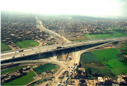
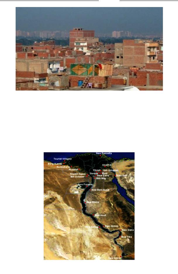
1. The causes of the construction of new towns in Egypt were overpopulation of existing towns, their massive deterioration, protection of agricultural lands from existing growing cities [3] (Fig. 1), increasingly worse housing conditions (Fig. 2), environmental issues, concentration of economic activities and services in existing towns.
Fig. 1. Growth of towns on agricultural land. Cairo, Egypt [3]
107
Scientific Herald of t he Voronezh State University o f Architecture and Civil Engineering. Construction and Architecture
Fig. 2. Degrading housing conditions in large cities
East of Alexandria, E gypt [4]
Up until 1973 all th e towns and residential areas wer e centered along the Nile valley. Following the end of the war ew towns were constru cted in the desert (Fig. 3) rich in deposits and accounting for 96% of Egy pt’s territory as part of social and economic evelopment. This strategy is in agreem nt with the goal to relocate the pop ulation fro m the Nile valley [5] and results in a shift of economic activities and urban services enabling to ma ke the most of the country’s territory.
Fig. 3. Egypt’s new to ns are indicated with red d ots (2014)
Source: http://ww w.newcities.gov.eg/english/New_Communities/default.aspx
108
Issue № 1(29), 2016 |
ISSN 2075-0811 |
2. Analysis of current conditions of Egypt’s new and existing towns. One of the major problems facing Egypt’s existing towns is overpopulation. In 2008 the average population density in Cairo was as large as 42286,7 inhabitants per km2. It should be noted that the population of Cairo in 2008 increased by 7 985,549 inhabitants and in Alexandria the density was about 2503,8 inhabitants per km2 [8]. In Borg El Arab in 2014 the population was 150 000 inhabitants with the average density of about 775 inhabitants per km2.
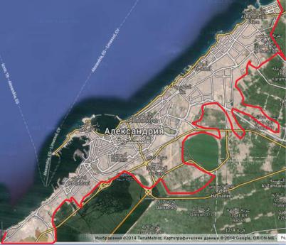
As far as degradation of existing towns is concerned, it should be noted that Cairo is the capital of Egypt and Middle East and Africa’s largest city. The metropolitan area of Cairo is the 16th largest in the world. Set in the Nile valley, the metropolitan area of Cairo is 86 369 km2 with the population of 19 439 541 as of 2011. The metropolitan area of Cairo includes five cities making up a huge agglomeration (Cairo, El Giza, 6th of October City, Helwan, Shoubra El Khaima). Alexandria (Fig. 4) is Egypt’s second largest city after Cairo with the population of 4,5 million, ~120 km of the Mediterranean coast in the central eastern part of the country [9]. This city is also one of the largest in the Mediterranean coast: the metropolitan area of Alexandria is 2136,97 km2 [10]. The living conditions in large cities are degrading due to the following: inadequate funding; not enough trained urban construction and management staff; the government’s failure to control the growth of cities (Fig. 4) into nearby areas. Cairo’s old areas are not properly maintained and developed resulting in increasingly deteriorating housing and infrastructure [11]. Furthermore, overpopulation, unemployment and insufficient food supplies are all too common.
Fig. 4. Location of Alexandria, expansion into rural areas around the city, 2014.
Source: https://maps.google.ru/maps?hl=ru&tab=wl
109
Scientific Herald of the Voronezh State University of Architecture and Civil Engineering. Construction and Architecture
3. Analysis of the developm ent of Borg El Arab. Borg El Arab is a new town [6, 7] (see Fig. 3). The construction of the city started in 1979. It was made part of the province of Alexandria a s decreed by the President on February 22, 1990.
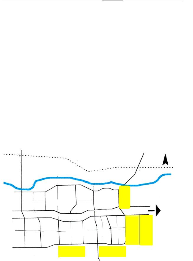
The planning structure of Borg El Arab (Fig. 5) includes two residential areas. The first one in the North consists of four averagely and scarcely populated residential quarters. The second one in the South is divided into five averagely and scarcely populated living quarters. All of them are homes to educational, administrative and commercial institutions. Both residential areas a re along the main city road which runs throughout the length of the city. In the city centre there is a major commercial centre and large green areas. Industrial areas are located in five areas in the South East and North East of the city [1, 13].
The city with clear boundaries (Fig. 4) is located 7 kilometers away from the Mediterranean coast and about 5 km away from Alexandria-Matruh road in the North of the cit y. In the South there is a settlement named after Murbarak populated by young specialists and the city of El-Hamam in the West. The city’s clear boundaries are marked with the Borg El Arab airport, Alexandria-Matruh road in the West, Namam Burgas road in the East, AlexandriaMatruh road in the North and the International Road, which is under construction, in the South.
Agricultural region
Seventh |
Fifth quarter |
Fourth |
|
|
|
||
quarter |
|
|
quarter |
Urban services |
Collector |
|
|
|
|
|
|
|
|
Collector |
|
Ninth |
Eighth |
Sixth quarter |
|
quarter |
quarter |
|
|
Industrial areas
First |
Industrial areas |
quarter |
|
Commercial centre
Third Second quarter quarter
Industrial areas
Industrial areas
North
Baheeg Canal
|
Borg El Arab, |
|
International |
Industrial areas |
Airport |
|
Fig. 5. Planning structure of Borg El Arab [13, p. 6]
110