Материал: [2.1] 3D Imaging, Analysis and Applications-Springer-Verlag London (2012)
366 |
A. Mian and N. Pears |
81.Silva, L., Bellon, O.R.P., Boyer, K.L.: Precision range image registration using a robust surface interpenetration measure and enhanced genetic algorithms. IEEE Trans. Pattern Anal. Mach. Intell. 27(5), 762–776 (2005)
82.Sirovich, L., Kirby, M.: Low-dimensional procedure for the characterization of human faces. J. Opt. Soc. Am. A 4, 519–524 (1987)
83.Spira, A., Kimmel, R.: An ecient solution to the eikonal equation on parametric manifolds. Interfaces Free Bound. 6(3), 315–327 (2004)
84.Swiss Ranger. Mesa Imaging. http://www.mesa-imaging.ch/. Cited 10 June, 2010
85.Tanaka, H., Ikeda, M., Chiaki, H.: Curvature-based face surface recognition using spherical correlation principal directions for curved object recognition. In: Int. Conference on Automated Face and Gesture Recognition, pp. 372–377 (1998)
86.Texas 3D face recognition database. http://live.ece.utexas.edu/research/texas3dfr/. Accessed 5th July 2011
87.Turk, M., Pentland, A.: Eigenfaces for recognition. J. Cogn. Neurosci. 3, 71–86 (1991)
88.Viola, P., Jones, M.: Robust real-time face detection. Int. J. Comput. Vis. 57(2), 137–154 (2004)
89.Xianfang, S., Rosin, P., Martin, R., Langbein, F.: Noise analysis and synthesis for 3D laser depth scanners. Graph. Models 71(2), 34–48 (2009)
90.Xu, C., Wang, Y., Tan, T., Quan, L.: Automatic 3D face recognition combining global geometric features with local shape variation information. In: Proc. IEEE Int. Conf. Pattern Recognition, pp. 308–313 (2004)
91.Yan, P., Bowyer, K.W.: A fast algorithm for ICP-based 3D shape biometrics. Comput. Vis. Image Underst. 107(3), 195–202 (2007)
92.Yang, M., Kriegman, D., Ahuja, N.: Detecting faces in images: a survey. IEEE Trans. Pattern Anal. Mach. Intell. 24(1), 34–58 (2002)
93.Yin, L., Wei, X., Sun, Y., Wang, J., Rosato, M.J.: A 3D facial expression database for facial behavior research. In: 7th Int. Conf. on Automatic Face and Gesture Recognition (FGR06), pp. 211–216 (2006)
94.Yu, H., Yang, J.: A direct LDA algorithm for high-dimensional data—with application to face recognition. Pattern Recognit. 34(10), 2067–2069 (2001)
95.Zhang, L., Snavely, N., Curless, B., Seitz, S.: Spacetime faces: high resolution capture for modeling and animation. ACM Trans. Graph. 23(3), 548–558 (2004)
96.Zhao, W., Chellappa, R., Phillips, P., Rosenfeld, A.: Face recognition: a literature survey. In: ACM Computing Survey, vol. 35, pp. 399–458 (2003)

Chapter 9
3D Digital Elevation Model Generation
Hong Wei and Marc Bartels
Abstract This chapter presents techniques used for the generation of 3D digital elevation models (DEMs) from remotely sensed data. Three methods are explored and discussed—optical stereoscopic imagery, Interferometric Synthetic Aperture Radar (InSAR), and LIght Detection and Ranging (LIDAR). For each approach, the state-of-the-art presented in the literature is reviewed. Techniques involved in DEM generation are presented with accuracy evaluation. Results of DEMs reconstructed from remotely sensed data are illustrated. While the processes of DEM generation from satellite stereoscopic imagery represents a good example of passive, multi-view imaging technology, discussed in Chap. 2 of this book, InSAR and LIDAR use different principles to acquire 3D information. With regard to InSAR and LIDAR, detailed discussions are conducted in order to convey the fundamentals of both technologies.
9.1 Introduction
A digital elevation model (DEM) is a digital representation of a terrain’s surface, created from terrain elevation data, with horizontal coordinates X and Y , and altitude Z. The methods used for DEM generation are roughly categorized as follows.
•DEM generation by passive remote sensors relying on natural energy sources like the sun. These could be airborne or spaceborne multispectral/panchromatic images evaluated as stereo-pairs to extract 3D information. This is also referred to as classical photogrammetry.
•DEM generation by active remote sensors, which sense artificial energy sources deliberately transmitted to a target. These include radar (Radio Detection And
H.Wei ( ) · M. Bartels
Computational Vision Group, School of Systems Engineering, University of Reading, Reading RG6 6AY, UK
e-mail: h.wei@reading.ac.uk
M. Bartels
e-mail: marc.bartels.berlin@gmail.com
N. Pears et al. (eds.), 3D Imaging, Analysis and Applications, |
367 |
DOI 10.1007/978-1-4471-4063-4_9, © Springer-Verlag London 2012 |
|

368 |
H. Wei and M. Bartels |
Ranging) stereo-pairs, InSAR (Interferometric Synthetic Aperture Radar), and LIDAR (LIght Detection And Ranging), which involves laser scanning.
•DEM generation by geodetic measurements. Geodetic instruments, which are integrated devices measuring lengths, angles, and levels of land surface, collect the
measured coordinates (X, Y ) and altitude (Z) point by point in a designated coordinate system (e.g. WGS841). With these data, a topographic map of the area is made with contour lines. Digitizing these contour lines and gridding them if needed, turns the hardcopy map to digital data format (i.e. DEM). This is a traditional method.
Techniques discussed in this chapter are mainly concerned with DEM generation from remote sensing, and cover both passive and active approaches. Three key remote sensing methods for DEM generation are discussed as optical stereo imaging, InSAR, and LIDAR. Although optical stereo images and InSAR data can be acquired from both airborne and spaceborne remote sensing, only spaceborne is considered in the discussion, whereas for an airborne representative, LIDAR is presented. A brief literature review of these three techniques in DEM generation is given in each of Sects. 9.2, 9.3, and 9.4, respectively.
There are three relevant technical terms that we need to distinguish: DEM, DTM (Digital Terrain Model), and DSM (Digital Surface Model). A DEM is a general term referring to an elevation model; a DSM is a surface model representing sensor detected height including all visible objects on the top of a surface; and a DTM is a terrain model showing bare ground surface topography. In using spaceborne stereoscopic imagery and InSAR to generate DEMs, there is hardly any difference between DSM and DTM due to the typical elevation accuracy of ±10 meters [38, 73], especially in rural areas where buildings and other man-made objects are absent from remotely sensed data. Under this circumstance, the term DEM is generally used to represent the 3D reconstruction in the photogrammetry and remote sensing community. However, with airborne LIDAR, the vertical accuracy and the capability to capture multiple returns (or echoes) necessitate the extension of the term DEM to the terms of DSM and DTM [143]. It is possible to remove objects and generate a more accurate DTM from the original DSM.
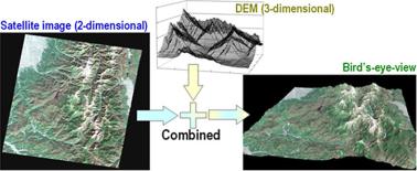
For many reasons, it has been a longstanding goal of mankind to be able to look at the Earth and find out what its surface or terrain looks like. With the development of remote sensing technologies and image interpretation techniques, it has become possible to see the Earth surface from a bird’s eye view, as shown in Fig. 9.1. Such data has been used to monitor changes in the Earth’s surface as a function of time, especially after natural disasters, such as volcanoes, earthquakes and tsunamis. It has also been used to predict land erosion and slides. In these applications, DEMs play an important role to recover the surface topography. Associated with co-registered satellite images, a vivid land surface can be displayed for visualization. Apart from visualization, DEMs are also required by many disciplines of scientific research involving studies of the Earth’s land surface, such as cartography, climate modeling,
1WGS84: World Geodetic Systems dating from 1984 and last revised in 2004.
9 3D Digital Elevation Model Generation |
369 |
Fig. 9.1 Bird’s eye view of a mountainous area from a 3D DEM mapped with texture from a satellite image. Copyright METI/NASA, reprinted with permission from ERSDAC (Earth Remote Sensing Data Analysis Center), http://www.ersdac.or.jp/GDEM/E/2.html
biogeography, geology, and soil science [80]. With the development of new remote sensing technologies with which data accuracy has dramatically improved, DEMs are also being used within an increasingly wide range of applications. These include site suitability studies for urban developments, telecommunications base stations and intelligent transportation systems, floodplain mapping and land erosion analysis, and applications in agriculture and forestry [105].
Chapter Outline After this introduction, the chapter is organized in the following main sections.
•Section 9.2 introduces DEM generation from stereoscopic imagery. In this section, a detailed literature review is presented on the technique, followed by accuracy evaluation. A step-by-step guide is given in an example of DEM generation from stereoscopic imagery.
•Section 9.3 discusses the principle and techniques for DEM generation from InSAR and accuracy analysis is conducted with regards to error sources. Examples of DEM generation from InSAR show the detailed process.
•Section 9.4 details DEM generation from LIDAR. It covers LIDAR data acquisition, data types and accuracy, and LIDAR interpolation. Comprehensive literature review is given for LIDAR filtering, an important step towards an accurate DEM (or DTM). The algorithm of Skewness Balancing in DEM generation from LIDAR is presented in detail.
•Section 9.5 discusses the research challenges remaining in the area of 3D DEM generation from remote sensing.
•Section 9.6 summarizes the chapter and lists clear learning targets for readers to achieve.
•Section 9.7 gives additional reading material for readers to further expand their knowledge in the areas of remote sensing, geographical information systems, and InSAR and LIDAR techniques.
370 |
H. Wei and M. Bartels |
•Finally a set of questions and exercises is provided in Sects. 9.8 and 9.9 respectively.
9.2 DEM Generation from Stereoscopic Imagery
Compared to the traditional manual methods that use human operators, automated methods of DEM generation from remote sensing provide efficient, economic and reasonably accurate products covering extended areas of the Earth’s surface. Remote sensing of the Earth’s surface started with photographic film cameras and has been evolving to digital cameras with selective sensing bands, for example, multispectral, thermal, hyperspectral, and radar. In this section, we discuss the issues associated with DEM generation from stereo images that are sensed from natural light in spaceborne missions. As with all stereo 3D reconstruction, two or more images that sense a scene with overlapping areas are required. A stereo image pair can be formed by along-track or across-track arrangement of sensors as shown in Fig. 9.2.
Along-track is defined by the forward motion of the satellite along its orbital path, whereas across-track refers to a satellite traveling on different orbits, hence images covering the same area are taken from different orbits. In general, a stereo pair captured in an along-track mission has a shorter time interval between two images than that captured in an across-track mission [101]. Thus variable weather conditions have less effect on along-track stereo pairs than on across-track stereo pairs in these passive imaging scenarios. The distance between two sensors is called the baseline (B), and the nadir distance (vertical distance) from satellite to ground is referred to as the height (H), as illustrated in Fig. 9.2. The base to height (B/H) ratio is a key parameter in DEM generation from stereoscopic imagery. It is a criterion for choosing an adequate number of stereo pairs from the same or different orbits. This section presents a literature review of the techniques used for DEM generation
Fig. 9.2 DEM generation from satellite stereoscopic imagery. The arrows refer to the satellite’s direction of flight. The low arrowed lines are the orthographic projection of the orbit onto the ground. Orbits 1 and 2 are two designated orbits that meet the requirements of stereo pairs. Left: Along-track. Right: Across-track