Материал: [2.1] 3D Imaging, Analysis and Applications-Springer-Verlag London (2012)

9 3D Digital Elevation Model Generation |
371 |
from remotely sensed stereoscopic imagery, followed by a discussion on quality evaluation of reconstructed DEMs. A step-by-step process to generate a DEM from a stereo pair is also presented.
9.2.1 Stereoscopic DEM Generation: Literature Review
The first space mission to provide stereoscopic imagery of the Earth’s surface was the American CORONA2 spy satellite program [52]. Over the past decades, a number of Earth observation satellites have been launched with high resolution imaging systems, such as Landsat (1972), IKONOS (1999), QUICKBIRD (2001), SPOT-5 (2002), ENVISAT (2002), ALOS (2006) and GeoEye-1 (2008). Stereo images acquired by these satellites can be along-track image pairs or across-track image pairs. DEM generation from a stereoscopic image pair involves the following processes [51, 68].
•Pre-processing of image pairs for noise removal: this is a process to mitigate the effects of noise introduced by the image sensors.
•Image matching: this is the process of finding corresponding points in two or more images and is implemented by either area-based or feature-based matching, or a combination of both.
•Triangulation process: image coordinates of matched points from the image pairs
are transformed into ground coordinates using the cameras’ interior and exterior parameters.3 This process involves geometric modeling of the satellite camera system and the ground coordinate system.
•Evaluation of the reconstructed DEM: this process can be achieved by means of ground control points (GCPs), if available.
As indicated in Marr and Poggio’s pioneering research on the computational theory of human stereo vision [109], there are two issues to address with respect to 3D reconstruction from stereo image pairs: correspondence and reconstruction (please refer to Chap. 2 of this book for the details). A key issue in automatic DEM generation is the process of image matching (solving the correspondence problem). Great efforts have been made by researchers from both remote sensing and computer vision communities in the 1980s [2, 11, 45, 57, 117, 130] to explore approaches in this field. In contrast to area-based cross-correlation, which dominated the field of image matching since the early 1950s, techniques developed in the period of the 1980s involved feature-based approaches. The combination of area-based and edgebased matching was attempted and applied by Förstner [45], Ackermann [2], and
2The CORONA program started in 1956 as a series of American strategic reconnaissance satellites. CORONA mission 9031 launched on 27th Feb. 1962 and was the first satellite providing stereoscopic images of the Earth.
3The terms ‘interior’ and ‘exterior’ are used in the DEM generation research community. In other research communities, such as computer vision, they are called ‘intrinsic’ and ‘extrinsic’ parameters, as discussed in Chap. 2.
372 |
H. Wei and M. Bartels |
Pertl [119] in DEM generation. Gruen developed a powerful model in which information from both image grey-level and first-order derivatives were incorporated for image matching [57]. With this model, adaptive least square correlation was performed to select the best match based on the fusion of point positioning with grey level information. It was claimed that the adaptive least square correlation provided a high matching accuracy. In terms of feature-based matching, Förstner and Gulch identified a series of feature points such as road intersections or centers of circular features which could be incorporated in matching algorithms [46]. Otto and Chau developed a region-growing algorithm for matching of terrain images [117]. They declared that their algorithm was an extension of Gruen’s adaptive least squares correlation algorithm so that whole images can be automatically processed, instead of only selected patches. It was demonstrated that the developed algorithm was capable of producing high quality and dense range maps when the scene being viewed had significant texture and few discontinuities. Feature-based algorithms in satellite stereo image matching complement the situations in which the scene has a sparse texture and presents large discontinuities.
In the 1990s, the development of passive stereo imaging techniques in the field of Computer Vision made it possible to have more automated solutions for DEM generation from stereoscopic imagery. Techniques, such as the stereo matching algorithm with an adaptive window [87], the coarse-to-fine pyramidal area correlation stereo matching method [116], and the robust approach for matching using the epipolar constraint [183] were adapted by the remote sensing community. By using the main principles of passive stereo vision from the Faugeras’ book [41], Gabet et al. worked out a solution for automatic generation of high resolution urban zone digital elevation models [51]. The work made use of an image sequence acquired with different base to height (B/H) ratios, hence, several stereo pairs are jointly used for DEM generation in a fixed area. With combinations of multiple algorithms covering both area-based and feature-based approaches, a fixed window size was used for cross-correlation in image matching. The authors claimed that the developed approach was universal to both airborne and spaceborne stereoscopic imagery, although only airborne data was tested due to the scope of the research. Wang [165] proposed an interesting structural image matching algorithm, in which an image descriptor was used for matching, which included points, lines, and regions structured by pre-defined relationships. The author demonstrated that the algorithm could achieve higher automation in DEM generation. The demand of automation for DEM generation within commercial software can also be seen in Heipke’s review paper [69] and significant improvements had been made to aerial stereo images in the 1990s.
In the 21st century, researchers have continued their efforts on automated DEM generation from satellite images and developed methodologies aimed at improving DEM accuracy and the level of automation. More robust computer vision algorithms were developed for stereo image matching [106]. Commercial software, such as PCI Geomatics, Desktop Mapping System, ERDAS Imagine, ENVI software, amongst others appeared on the market including algorithms for automated DEM genera-

9 3D Digital Elevation Model Generation |
373 |
tion from stereoscopic imagery. Hirano et al. [73] examined ASTER4 stereo image data for DEM generation. ASTER provides along-track stereo image data in nearinfrared with a 15 m horizontal resolution at a B/H ratio of 0.6. Computed elevations from commercial software were compared with results from topographic map and USGS5 DEMs at a few testing sites and conclusions were made that DEMs generated from ASTER could expect ±7 m to ±15 m elevation accuracy and up to 99 % correlation success rate with images of good quality and adequate ground control. Lee, et al. [98] argued that DEM generation from satellite images was timeconsuming and error-prone. This was due to the fact that most DEM generation software used for processing satellite images was originally developed for aerial photos taken by perspective cameras, while satellite images may be formed by linear pushbroom cameras. Hence, image matching and geometric modeling implemented in the software for aerial photos had to be modified for satellite imaging applications. In their paper, linear pushbroom cameras were modeled with the geometric properties in designing the matching strategy optimized in three aspects: conjugate search method, correlation patch design, and match sequence determination. It was claimed that the developed approach was universal for linear pushbroom images with various correlation algorithms and sensor models. DEM generation from SPOT-5 stereoscopic imagery was investigated in [21, 92, 125, 150]. SPOT-5 is equipped with two High Resolution Stereoscopic (HRS) cameras that are tilted ±20◦ to acquire stereo pairs of 120 km swath, along the track of the satellite with a B/H ratio of 0.8, and the nadir looking-HRG (high resolution geometric) panchromatic camera providing additional images. HRS has a horizontal resolution of 10 m and HRG has a resolution of 5 m. A summary of the SPOT-5 payload and mission characteristics is given in [21]. In the above work, bundle adjustments were conducted to correct cameras’ interior and exterior parameters in the geometric model. The best result was claimed in [150] with the vertical accuracy of 2.2 m for a smooth bare surface. In general, the DEM generated from SPOT-5 stereo images could achieve 5–10 m elevation accuracy with accurate and sufficient GCPs. DEMs generated from the IKONOS triplet (forward, nadir and backward) of stereoscopic imagery were investigated by Zhang and Gruen [182]. In their work, a multi-image matching approach was developed by using a coarse-to-fine hierarchical solution with an effective fusion of several matching algorithms and automatic quality control. It was reported that the DSM achieved 2–3 m elevation accuracy in the test area. With this accuracy, it is possible to consider DTMs to be extracted from the DSMs.
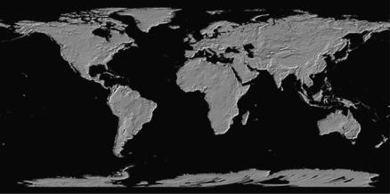
In June 2009, Japan’s Ministry of Economy, Trade and Industry (METI) and NASA6 jointly announced the release of Global Digital Elevation Model (GDEM) by stereo-correlating about 1.3 million scenes from ASTER data [85], as shown in Fig. 9.3. It has been indicated in its validation summary report [9] that ASTER
4ASTER: Advanced Spaceborne Thermal Emission and Reflection Radiometer, an imaging instrument flying on Terra satellite launched in December 1999 as part of NASA’s Earth Observing System.
5USGS: United States Geological Survey.
6NASA: National Aeronautics and Space Administration.
374 |
H. Wei and M. Bartels |
Fig. 9.3 Global DEM from ASTER. Copyright METI/NASA, reprinted with permission from ERSDAC, http://www.ersdac.or.jp/GDEM/E/4.htm
GDEM covers land surfaces between 83◦N and 83◦S with estimated accuracy of 20 m at 95 % confidence for vertical data and 30 m at 95 % confidence for horizontal data. Although ASTER GDEM was found to contain significant anomalies and artifacts, METI and NASA decided to release it for public use with belief of its potential benefits outweighing its flaws and with expectation of improving it via the user community.
Research into DEM generation has also expanded to Mars by a combination of stereoscopic imagery and the Mars orbiter’s laser altimeter [58]. It can be foreseen that there will be the following improvements.
1.Further evaluation of geometric models to adaptively correct DEM errors caused by sensor platform attitude instability.
2.Development of more robust image matching algorithms for increasing automation and matching coverage.
For advanced stereo vision techniques that can be used for DEM generation from stereoscopic imagery, please refer to Chap. 2 of this book.
9.2.2 Accuracy Evaluation of DEMs
Quantitative evaluation of DEMs generated by satellite stereoscopic imagery can be conducted by comparing the reconstructed elevation values with GCPs collected by ground surveys or compared with corresponding DEMs generated by higher accuracy devices, such as LIDAR. In both cases, the measure of Root Mean Square Error

9 3D Digital Elevation Model Generation |
375 |
(RMSE) is used in assessing the DEM accuracy. It is defined as
RMSE = |
|
|
n |
h |
2 |
(9.1) |
|
i |
=n |
i |
|||||
|
|
|
1 |
|
|
||
where n is the number of assessed points in evaluation, and h is the height difference between the assessed DEM and GCPs or reference DEM at point i. The standard deviation of the height difference can be calculated in Eq. (9.2).
σ = |
|
|
i=1 |
ni − ¯ |
|
|
|
(9.2) |
|
|
|
n |
( h h)2 |
|
|
||
where the mean height difference is given as ¯ |
1 |
n |
hi . Assuming that |
|||||
= n |
i=1 |
|||||||
|
|
|
|
h |
|
|
|
|
the measured data has a normal distribution, ±1σ gives 68 % level of confidence and ±2σ gives 95 % level of confidence in measurements. In the remote sensing community, the elevation accuracy is usually represented by RMSE with a level of confidence, for example, 20 m with LE95 (Linear Error with confidence of 95 %).
Possible error sources are considered in order to improve DEM accuracy. Error propagation can be tracked along the processes of DEM generation, for example, errors due to image matching and 3D reconstruction from the geometric modeling. Geometric modeling to recover elevations from stereo images is the well-known perspective projection from image coordinates to cartographic coordinates. The projection involves elementary transformations (rotations and translations), which are functions of the cameras’ interior and exterior parameters. This requires prior knowledge of the cameras, platforms, and cartographic coordinate systems. Based on such prior knowledge, a rigorous model based on collinearity conditions can be used for DEM generation. This geometric model integrates the following transformations [149, 150], where the xoy refers to the image coordinate system, rotations and translations are also referred to images, and the z-axis represents the direction perpendicular to the image common plane (usually same as the z-axis to the cartographic system).
•Rotation from the camera reference to the platform reference.
•Translation to the Earth’s center (refers to the cartographic coordinate system).
•Rotation that takes into account the platform variation over time.
•Rotation to align the z-axis with the image center on the Earth’s surface.
•Translation to the image center.
•Rotation to align the y-axis in the meridian plane.
•Rotation to have xoy (the image plane) tangential to the Earth.
•Rotation to align the x-axis in the image scan direction.
•Rotation-translation into the cartographic coordinate system.
With the geometric model and possible errors introduced by each step of the process, the integration of different distortions and their impact to the final elevation can be derived [147]. In the derivation, each of the model parameters is the combination of several correlated variables of the total viewing geometry. These include the following.