Материал: [2.1] 3D Imaging, Analysis and Applications-Springer-Verlag London (2012)
438 |
H.-E. Andersen |
Fig. 10.9 Relationship between (transformed) fieldand LIDAR-based estimates of aboveground tree biomass (MG/ha) for seventy-nine (79) plots in the upper Tanana valley of interior Alaska
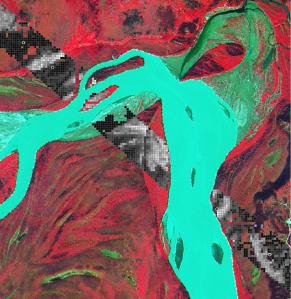
Fig. 10.10 Example of LIDAR-derived biomass measurements (black: low biomass, white: high biomass) within single LIDAR swath, upper Tanana valley of interior Alaska. Background is a false-color SPOT 5 image (2.5 meter resolution), and circles represent field plots (with same color ramp as the LIDAR grid cells)
This model is then applied to each grid cell within the LIDAR coverage area (where the grid cell size is a comparable grain size as the field plots (i.e. 1/30th hectare 18 m × 18 m grid cells) (see Fig. 10.10).
The LIDAR-based estimates of precision acquired over the coverage area can then be used to develop estimates of total (or mean) biomass. Due to the interest (to date) in using LIDAR to acquire better topographical information, most LIDAR
10 High-Resolution Three-Dimensional Remote Sensing for Forest Measurement |
439 |
acquisitions are wall-to-wall acquisitions, and in this case the LIDAR data is, from a statistical standpoint, a complete census of the population. In very remote and extensive areas, the cost of obtaining wall-to-wall LIDAR coverage may be prohibitive, and in this case LIDAR may be acquired in a strip sampling mode [2, 3, 18]. The area-based approach to estimating biomass consists of the following steps:
1.Filter out ground-level LIDAR points.
2.Grid filtered ground-level points into digital terrain model (DTM).
3.Extract LIDAR point cloud within each field inventory plot area.
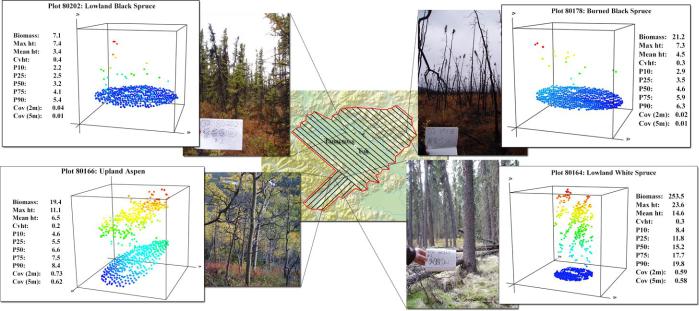
4.Generate structural metrics from extracted LIDAR point cloud (maximum height, mean height, canopy cover, height percentiles, etc.) (Fig. 10.8).
5.Develop regression model to predict plot-level biomass using LIDAR structural metrics as predictor variables (Fig. 10.9).
6.At each grid cell over the entire LIDAR coverage area (where the grid cell area corresponds to the field plot area), extract the same LIDAR structural metrics as in Step 4 above.
7.Apply the regression model developed in Step 5 above to predict biomass within each grid cell (Fig. 10.10).
8.Use resulting map of biomass to estimate (mean or total) biomass over entire LIDAR coverage area.
10.4 Future Developments
It should also be noted that both airborne digital imaging systems and laser scanners will continue to develop and provide increasingly accurate, precise, and information-rich measurements. For example, the increasing availability of full waveform, discrete-return airborne LIDAR has the potential to significantly increase the spatial resolution at which we measure and characterize canopy structure [45, 52, 54]. The coupling of high-resolution hyperspectral and multispectral imagers with high-density airborne scanners, or eventually the development of a true multispectral LIDAR system, has tremendous potential for simultaneously determining vegetation condition, species, and spatial dimension [3, 33].
10.5 Concluding Remarks
The convergence of a new generation of high-resolution remote sensing systems, including digital imagery and airborne laser scanning, advanced geopositioning technologies, and ever-increasing computational capability has led to dramatic improvements in our ability to measure and characterize forests from remote platforms over the last 10–15 years. Forest inventory specialists can now extract detailed tree height measurements and individual tree attributes from high-resolution, lowaltitude stereo digital imagery. High-density airborne LIDAR data can also be used
440 |
H.-E. Andersen |
to extract detailed information on individual tree dimensions and attributes through the application of automated image analysis algorithms. In areas where individual tree-based analysis is not appropriate or feasible, due to the data resolution or forest characteristics, area-based LIDAR analysis techniques can be used to develop spatially-explicit information for various inventory parameters across the landscape, which in turn can provide highly useful information to support forest management applications.
10.6 Further Reading
More details on analytical and digital photogrammetry can be found in the texts by Wolf [56] and Mikhail et al. [32]. Basic formulas and technical details related to airborne LIDAR scanning are provided in the article by Baltsavias [4]. Further background on field-measurement of individual trees and a comparison to LIDARbased tree heights are found in [1], and further background on the principles of full-waveform airborne laser scanning are found in [54]. Further details on the principles of LIDAR-based individual-tree detection and measurement are provided in [20] and [41]. Details on using LIDAR intensity and crown structure to determine individual tree species type are provided in [22] and [19]. Further reading on the areabased approach to estimating biomass using airborne LIDAR is provided in [35].
10.7 Questions
1.This question is about the effect of the quality of digital imagery on the measurement of tree heights:
a.Describe the data requirements for measuring tree heights from stereo digital imagery.
b.Describe how image motion affects the quality of digital imagery and how this can be mitigated.
2.Describe the expected accuracy of manual tree height measurements acquired from airborne LIDAR and how these may be affected by species and sensor settings.
3.Explain the difference between an individual-tree and area-based approach to estimating biomass using airborne LIDAR. When would an area-based approach be preferable to an individual tree approach?
4.Describe one technique for automatically extracting individual tree measurements from LIDAR.
5.List five LIDAR-based structural metrics that can be used in the area-based LIDAR biomass estimation technique.
10 High-Resolution Three-Dimensional Remote Sensing for Forest Measurement |
441 |
References
1.Andersen, H.-E., Reutebuch, S., McGaughey, R.: A rigorous assessment of tree height measurements obtained using airborne LIDAR and conventional field methods. Can. J. Remote Sens. 32(5), 355–366 (2006)
2.Andersen, H.-E., Strunk, J., Temesgen, H.: Using airborne light detection and ranging as a sampling tool for estimating forest biomass resources in the upper Tanana Valley of interior alaska. Western J. Appl. For. 26(4), 157–164 (2011)
3.Asner, G., Knapp, D., Jones, M., Kennedy-Bowdoin, T., Martin, R., Boardman, J., Field, C.: Carnegie airborne observatory: in-flight fusion of hyperspectral imaging and waveform light detection and ranging for three-dimensional studies of ecosystems. J. Appl. Remote Sens. 1(1) (2007)
4.Baltasavias, E.: Airborne laser scanning: basic relations and formulas. ISPRS J. Photogramm. Remote Sens. 54, 199–214 (1999)
5.Baltsavias, E., Gruen, A., Kuchler, M., Thee, P., Waser, L., Zhang, L.: Tree height measurements and tree growth estimation in a mire environment using digital surface models. In: Proceedings of the Workshop on 3D Remote Sensing in Forestry, Feb. 14–15, 2006, Vienna, Austria (2006)
6.Bater, C., Coops, N.: Evaluating error associated with LIDAR-derived DEM interpolation. Comput. Geosci. 35(2), 289–300 (2009)
7.Bechtold, W., Patterson, P. (eds.): The enhanced forest inventory and analysis program, national sampling design and estimate procedures. Gen. Tech. Rep. SRS-80, Asheville, NC, U.S. Department of Agriculture, Forest Service, Southern Research Station, 85 p. (2005)
8.Ben-Arie, J., Hay, G., Powers, R., Castilla, G., Onge, B.St.: Development of a pit filling algorithm for LiDAR canopy models. Comput. Geosci. 35(9), 1940–1949 (2009)
9.Brandtberg, T., Walter, F.: Automated delineation of individual tree crowns in high spatial resolution aerial images by multiple scale analysis. Mach. Vis. Appl. 11, 64–73 (1998)
10.Culvenor, D.: TIDA: an algorithm for the delineation of tree crowns in high spatial resolution remotely sensed imagery. Comput. Geosci. 28(1), 33–44 (2002)
11.Delara, R., Mitishita, E., Habib, A.: Bundle adjustment of images from non-metric CCD camera using LIDAR data as control points. Int. Arch. Photogramm. Remote Sens. 35(B3), 470– 475 (2004)
12.Falkowski, M.J., Smith, A.M.S., Hudak, A.T., Gessler, P.E., Vierling, L.A., Crookston, N.L.: Automated estimation of individual conifer tree height and crown diameter via Twodimensional spatial wavelet analysis of LIDAR data. Can. J. Remote Sens. 32(2), 153–161 (2006)
13.Gatziolis, D.: Dynamic range-based intensity normalization for airborne, discrete return LIDAR data for forest canopies. Photogramm. Eng. Remote Sens. 77(3), 251–259 (2011)
14.Gaveau, D., Hill, R.: Quantifying canopy height underestimation by laser pulse penetration in small-footprint airborne laser scanning data. Can. J. Remote Sens. 29(5), 650657 (2003)
15.Gong, R., Sheng, Y., Biging, G.: 3D model-based tree measurement from high-resolution aerial imagery. Photogramm. Eng. Remote Sens. 68(11), 1203–1212 (2002)
16.Goodwin, N., Coops, N., Culvenor, D.: Assessment of forest structure with airborne LIDAR and the effects of platform altitude. Remote Sens. Environ. 103(2), 140–152 (2006)
17.Gougeon, F.A.: Crown-following approach to the automatic delineation of individual tree crowns in high spatial resolution aerial images. Can. J. Remote Sens. 21(3), 274–284 (1995)
18.Gregoire, T., Stahl, G., Naesset, E., Gobakken, T., Nelson, R., Holm, S.: Model-assisted estimation of biomass in a LiDAR sample survey in Hedmark county, Norway. Can. J. For. Res. 41, 83–95 (2010)
19.Holmgren, J., Persson, A.: Identifying species of individual trees using airborne laser scanner. Remote Sens. Environ. 90(4), 415–423 (2009)
20.Hyyppa, J., Kelle, O., Lehihoinen, M., Inkinen, M.: A segmentation-based method to retrieve stem volume estimates from 3D tree height models produced by laser scanners. IEEE Trans. Geosci. Remote Sens. 39, 969–975 (2001)